Florian Heigl
Writing History: Letters 1914-1919
What is the project about?
The crowdsourcing project "Letters 1914-1919" is about the transcription of the unique letter collection of the Vienna City Library from this period. In contrast to historical printed works, which are now subjected to automatic full-text recognition as standard, this is still not so easy to do for manuscripts - especially when the documents come from many different writers, as in this case. Since the democratization of knowledge plays a central role in the range of tasks of the Vienna City Library and only readable and comprehensible knowledge can be brought to life, the idea arose to ask the crowd for help in indexing the content. The historically significant period from 1914 to 1919 was chosen as the starting point.
The Vienna City Library will digitize all correspondence - more than 200,000 items - by 2025 and make them freely available in the Digital Library in compliance with copyright law. Due to the alphabetical approach, the crowdsourcing project's holdings will successively expand up to the letter Z.
How can one contribute?
Participation is open to all interested persons. After registering, you can choose between two tasks: Transcribe letters or check letters already transcribed by others. If errors are discovered, they can be changed and a new version created. Three independent confirmations are necessary for a transcription to be classified as correct.
What happens to the results?
The finished transcriptions are integrated into the Digital Library of the Vienna City Library at regular intervals and can then be retrieved and searched at any time. This makes the contents of the letters accessible to all interested persons - something that was previously reserved for a limited circle of experts.
Crowdsourcing platform crowdsourcing.wien
The project "Letters 1914-1919" is part of the crowdsourcing platform crowdsourcing.wien - a cooperation of Wien Museum and Vienna City Library. The aim of this joint platform is to make original sources on the history of Vienna from various institutions accessible to all interested persons with the help of the crowd. Because only knowledge that can be read and comprehended can be brought to life and made available for inclusive debate.
More information: New platform crowdsourcing.wien and "Letters 1914-1919" www.wienbibliothek.at/ueber-uns/presse/presseaussendungen/neue-plattform-crowdsourcingwien-briefe-1914-1919
Podcast episode
In July 2023, project coordinator Alexandra Egger was guest on the Österreich forscht podcast Wissen macht Leute - you can listen to the episode here (in German).
Picture gallery
-
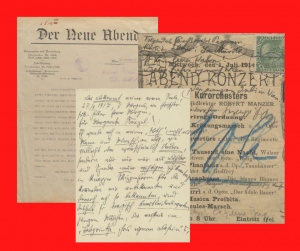
 Letter from Franz Josef Böhm to Marie von Ebner-Eschenbach, 24.4.1914, HIN-130022, Vienna City Library Letter from Franz Josef Böhm to Marie von Ebner-Eschenbach, 24.4.1914, HIN-130022, Vienna City Library
 - Letter from Herberg Eulenberg to Franz Servaes, 13.6.1917, HIN-137743, Vienna City Library Letter from Herberg Eulenberg to Franz Servaes, 13.6.1917, HIN-137743, Vienna City Library
- Postcard from Raoul Auernheimer to Johannes Wilhelm Auernheimer from Constantinople, 8.5.1914, HIN-154569, Vienna City Library Postcard from Raoul Auernheimer to Johannes Wilhelm Auernheimer from Constantinople, 8.5.1914, HIN-154569, Vienna City Library
- Letter from Friedrich Bitterlich an Richard Weiskirchner, 26.3.1915, HIN-214005, Vienna City Library Letter from Friedrich Bitterlich an Richard Weiskirchner, 26.3.1915, HIN-214005, Vienna City Library
- Letter from Richard Beer-Hofmann to Theodor Reik, 23.11.1917, HIN-247438, Vienna City Library Letter from Richard Beer-Hofmann to Theodor Reik, 23.11.1917, HIN-247438, Vienna City Library
- Letter from Peter Altenberg to Margarete Frenzel, 27.9.1917, HIN-248841, Vienna City Library Letter from Peter Altenberg to Margarete Frenzel, 27.9.1917, HIN-248841, Vienna City Library
- Letter from Lily Braun to Friedrich Umlauft, 1.4.1914, HIN-35245, Vienna City Library Letter from Lily Braun to Friedrich Umlauft, 1.4.1914, HIN-35245, Vienna City Library
- Letter from Leo Ascher to Ben Tieber, 9.9.1918, HIN-39713, Vienna City Library Letter from Leo Ascher to Ben Tieber, 9.9.1918, HIN-39713, Vienna City Library
- Letter from Marie von Ebner-Eschenbach to Auguste Wilbrandt-Baudius, 25.1.1914, HIN-56820, Vienna City Library Letter from Marie von Ebner-Eschenbach to Auguste Wilbrandt-Baudius, 25.1.1914, HIN-56820, Vienna City Library
- Letter from Henriette von Bombelles to Richard von Kralik, 13.4.1914, HIN-97626, Vienna City Library Letter from Henriette von Bombelles to Richard von Kralik, 13.4.1914, HIN-97626, Vienna City Library


https://www.citizen-science.at/en/component/k2/author/934-florianheigl?start=70#sigProId1358efc294
This project fulfils version 1.1 of the quality criteria for citizen science projects on Österreich forscht.
ABCs of Dialect
Language is one of the most important means of human communication, an essential part of our culture and it can also fulfill an identity-forming function. At the same time, it is constantly changing with the society that uses it. There are words that were used a century ago, but that no one knows today. Simultaneously, there are other words are still in use but have changed their meaning.
With the "ABCs of Dialect" you can rediscover old German dialect words and help us process the linguistic and cultural heritage of the Bavarian-Austrian language area!
What is it about?
Citizens have always played a significant role in linguistics. Especially in the field of lexical variation – long before the term Citizen Science was established – they were not only passive suppliers of linguistic data, but actively participated in its collection. A prominent example is the “Wörterbuch der bairischen Mundarten in Österreich” (WBÖ) (‘Dictionary of Bavarian Dialects in Austria’), whose data was originally gathered by citizens. Already since 1914, this project has been dedicated to the comprehensive documentation and lexicographic analysis of the rich and unique dialect landscape of (historical) Austria. Now we want to invite citizens back to process and evaluate the data and to (re)discover their linguistic and cultural heritage.
The basis for the WBÖ is data from the so-called ‘Hauptkatalog’ (‘main catalogue’), a collection of paper slips covering approximately 3.6 million entries with dialect samples that were collected in the first half of the 20th century. The major part of the dialect data in this collection was obtained indirectly with the help of so-called collectors (“Sammler”) on the basis of questionnaires. While a large part of the paper slips (from letter D onwards) has already been digitized for editorial and archival reasons and is publicly accessible as a database via the Lexikalisches Informationssystem Österreich (LIÖ) (‘Lexical Information System Austria’), only the physical paper slips for letters A, B/P and C as well as scans exist. At this point, the project “The ABCs of dialect: exploring historical notes digitally” starts.
What are the tasks of the citizens?
- Citizens transcribe original WBÖ paper slips (collection of letter A to C) and thus help complete the already existing WBÖ database.
- Citizens reflect on the content of the 100-year-old paper slips with regard to current dialect usage and hence are integrated into analyses of dialect change in the course of the last 80-100 years. (e.g.: Is a dialect word still in active use in Austria? Has the meaning of a particular word changed?).
In this way, interested persons (particularly from Austria, but not limited to) should be given access to their linguistic and regional heritage. In addition, by dealing with the historical information, a reflection on current language use and a connection to current research on vocabulary, language use and language change should be established.
How can I participate?
Citizens can participate via the Zooniverse platform by transcribing old paper slips and the handwritings on them. In addition, they can reflect on their own or general current language use by answering questions about the words they have copied, e.g. whether they still know the word or even use it themselves.Participation is possible anywhere and anytime via the Zooniverse platform. The only requirement is internet access. Not necessary but very helpful is the ability to read Kurrent handwriting, which was used on some of the paper slips.
At introductory workshops, citizen scientists are familiarised with the platform and the paper slips and trained in the tasks. In the course of this, some participants are trained as experts who other participants can then turn to. However, it is also possible to contribute to the project without prior training.
Who can participate?
Everyone who is interested in language or dialects and the cultural heritage of Austria is invited to contribute to the “ABCs of dialects”. We want to involve both younger and older Citizen Scientists, since older people typically have high dialect skills and are still familiar with the diverse handwriting systems that we find on the paper slips in the collection, while younger people have high digital skills. In this way we bring generations and their skills and abilities together and encourage intergenerational collaboration. At the same time, their competence and knowledge are not only valued, but also made visible to the outside world in a linguistic and cultural context.
A special added value of the project consists in that the historical material, which was collected about 100 years ago using citizen science methods (even if they were not called such at the time), is made accessible to the citizens and they contribute to the evaluation and transcription of this historic material.
Further information at https://abc-mitmachen.acdh.oeaw.ac.at/.
Podcast episode
As part of the episode "The Citizen Science Award 2024 - behind the scenes", Cornelia Sommer-Hubatschke, teacher at BG & BRG Stockerau, who took part in the ABCs of Dialect with a school class, talked about her experiences in the project in the podcast Wissen macht Leute. You can listen to the episode on our blog or on the podcast app of your choice (the episode is in German). You can find all the details here.
In addition, Rebecca Stocker and Philipp Stöckle gave a behind-the-scenes look at the project in the episode 'The ABC of Dialects'. Details of this episode can be found here.
Picture gallery
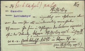
- paper slip from Vienna on the word Erdapfel paper slip from Vienna on the word Erdapfel
- paper slip from Moschendorf on the word alles paper slip from Moschendorf on the word alles
- paper slip from Reidling on the word Federpennal paper slip from Reidling on the word Federpennal
- paper slip from Weidenthal on the word Pfiffikus paper slip from Weidenthal on the word Pfiffikus


https://www.citizen-science.at/en/component/k2/author/934-florianheigl?start=70#sigProId63e260d44f
This project fulfils version 1.1 of the quality criteria for citizen science projects on Österreich forscht.
The Psychological is Participatory
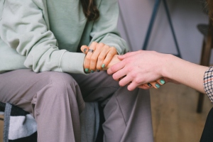
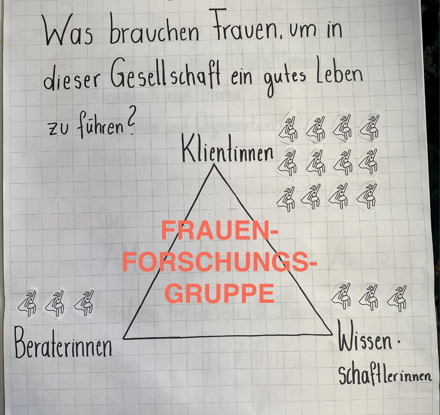
Counselling centres for women* are important institutions that have been founded since the 1980s by the second women's movement. In the project, researchers are conducting research together with counsellors and clients of Viennese women's* counselling centres. We are interested in the life stories of women* who seek help at counselling centres. How can women lead a good life in this society today and what role can women's counselling play in this? In workshops, questions and methods are developed together with the project partners. The women* and the counsellors are guided to document their knowledge and experiences in the form of narrated stories or/and with visual methods. The use of a critical participatory action approach enables both counsellors and clients to reflect on changes that have occurred through a feminist, psychological counselling process.
The perspective of women clients has very rarely been considered in the history of psychology. Especially structurally disadvantaged women* are often not heard, e.g. migrant women or single parents affected by poverty. Research with clients aims to empower women* and to explore with them how social circumstances have shaped their lives.
"The Psychological is Participatory - Feminist critical participatory action research with women's counselling centres and their clients" (2022-2023), funded by the Austrian Science Fund FWF (TCS 112 Top Citizen Science) and co-financed by the Women and Family Department of the Arbeiterkammer.
Project management: Ass.-Prof. Dr. Nora Ruck
Project team: Dr. Barbara Rothmüller, Julia Struppe-Schanda, MSc.
In the project we are conducting research together with Dr. Bettina Zehetner from the counselling centre Frauen* beraten Frauen* and Dr. Sigrid Awart and Dr. Andrea Kaiser-Horvath from the counselling centre Peregrina as well as with 12 clients from both counselling centres*. Prof. Michelle Fine & Prof. María Elena Torre (CUNY), Prof. Thomas Stefan (Postdam) and Prof. Alexandra Rutherford (Toronto) advise us on the Advisory Board of the project. The project is scheduled to be completed in December 2023.
*Participation is restricted to these clients.
Podcast episode
In April 2025, Nora Ruck was a guest on the Österreich forscht podcast Wissen macht Leute - you can listen to the episode here (in German).
![]()
This project fulfils version 1.1 of the quality criteria for citizen science projects on Österreich forscht.
SoilPlastic
SoilPlastic is a citizen science project that collects data on plastic in soils. No prior knowledge is needed to participate and you can enter your observations in the SoilPlastic app in just a few minutes.
What is it about?
Plastic products and their remains are ubiquitous. However, we still know little about how much and which types of plastic end up in soils and what effects this has. Observations by citizen scientists help scientists to fill this knowledge gap. This is an important field of (citizen) science, as we rely on soils to produce 95% of our food.
How can you participate?
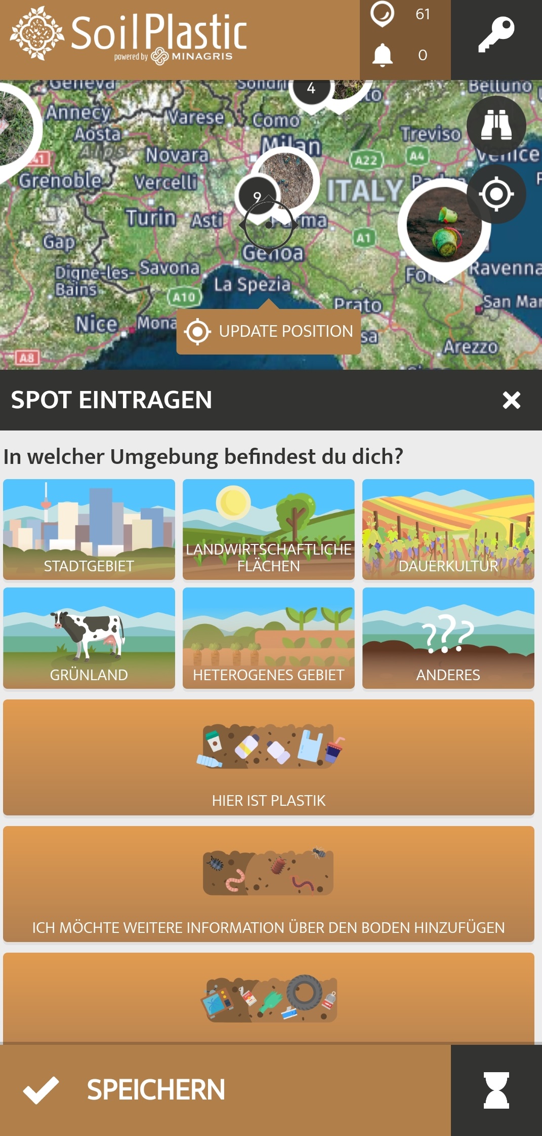
With the SoilPlastic app for Android and iOS, observations can be entered anywhere and at any time. Entries can also be made via the browser in the web-based app. So if you spot plastic in the environment while walking, cycling or on your way to work/school, enter your observation as a "spot" in the app. GPS localisation on your smartphone should be activated so that the spot is automatically placed in the right location. A spot needs at least information about the amount and size of the plastic found, about the surroundings (field, park, etc.) and a photo of your observation.
Other details are optional: colour of the plastic, type of plastic, information about the soil (texture, soil life), other material found. This will help the research team to understand the distribution of plastic and the site more precisely. Of course, the environment will be happy if you take the found objects with you and dispose of them in the correct waste bin.
What do I get out of it as a citizen scientist?
The citizen scientists become part of the EU research project MINAGRIS (Micro- and Nanoplastics in Agricultural Soils) and make an important contribution to a clean environment by adding knowledge and collecting the found objects from the environment and disposing of them properly. You will also learn new things about plastics, soil and (citizen) science in a fun way. Furthermore, the SoilPlastic app allows you to connect with other Citizen Scientsts who probably have similar interests. As the SoilPlastic app is part of the citizen science platform Spotteron, you can use the same account as in other Spotteron apps and communicate about different topics and projects.
What is the data used for?
The collected data is used in the MINAGRIS project to get an overview of the amount and type of visible plastic on soils. MINAGRIS investigates the effects of plastic on soils and biodiversity and develops a sustainable use of plastic. The spots in the SoilPlastic app are also visible to everybody interested.
Interactive map:
Links:
Zoom into Soil: Microplastics: Webinar of the British Society of Soil Science about microplastic in soils
MINAGRIS is funded by the European Union's Horizon2020 programme for research and innovation under contract number 101000407.
Picture gallery


https://www.citizen-science.at/en/component/k2/author/934-florianheigl?start=70#sigProId9c4b79d76d
Development of the app by Spotteron
![]()
SoilPlastic is part of the EU project MINAGRIS
![]()
This project fulfils version 1.1 of the quality criteria for citizen science projects on Österreich forscht.
Phänoflex
Flexibilisation of WF-mowing dates according to the phenological model
The ÖPUL-measure Nature Conservation results in farmers usually having an agreement on a fixed mowing date. Due to the ongoing climate change, vegetation development fluctuates more and more especially during spring and early summer. Therefore, it was proposed to expand the flexibility of harvest date requirements. For this purpose, over a hundred farmers all over Austria started to observe the course of panicle development and the blooming of black elderberry. Based on this data, a phenological model is calculated for each region. During a warm year with an early onset of vegetation development, the farms can mow their meadows before the date given by the project confirmation. The new, earlier date is then communicated via www.mahdzeitpunkt.at.
Roles and responsibilities
Project lead
Austrian council for agricultural engineering and rural development
Project partners
GeoSphere Austria (former Central Institute for Meteorology and Geodynamics)
Modeling of the annual vegetation development with the additional inclusion of weather data from GeoSphere Austria. Analysis and handling of meteorological data and phenology data from GeoSphere in cooperation with experts.
LACON landscape planning consulting
Modeling of the annual vegetation development with the additional inclusion of weather data from GeoSphere Austria as well as annual organization and supervision of the observations by the Citizen Scientists.
Citizen Scientists
Monitoring and documentation of the phenology of cock's-foot and elder
This project fulfils version 1.1 of the quality criteria for citizen science projects on Österreich forscht.
Hero
DESIGNING AN INFORMATION TOOL FOR CARDIAC REHABILITATION
Background
Previous research has shown that after an acute cardiac event, such as a heart attack, patients can feel uninformed about the follow-up care and cardiac rehabilitation. Digital technologies have the potential to make health-related information available at any time and in a layman-friendly manner.
The aim of the project was to develop a digital prototype that provides patients with information regarding cardiac rehabilitation following an acute cardiac event.
The HERO-Project
The HERO co-design workshop series was carried out in collaboration between four scientists from the Ludwig Boltzmann Institute for Digital Health and Prevention (LBI DHP) and a total of 16 research partners (ten cardiac patients, six healthcare professionals and one professional with a cardiac patient history).
The workshops were based on the principles of generative co-design. In addition to presentations and group work, which enabled an exchange of experiences, the following methods were used to answer the questions: A brainstorming session in an acute hospital setting to prioritise information and to discuss where to possibly place information in the hospital. Afterwards, paper prototypes were designed to identify latent needs and to define requirements for a digital information support tool. Figure 1 shows impressions from the workshops.
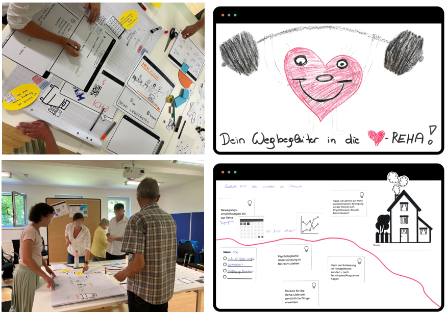
Figure 1. Impressions from the co-design group work.
Based on the results of the co-design workshops, a digital prototype was developed that addresses the expressed needs and contains the defined requirements. The next step will be to develop an app, which will then be tested by cardiac patients in the acute hospital setting.
Get involved!
We are always looking for people who are interested in testing our app! Currently we are looking for:
- Cardiac patients who participated in a cardiac rehabilitation programme
- Healthcare professionals from the cardiology sector (nursing staff, therapists, doctors...)
Please feel free to get in touch with us!
Additional information and contact
Isabel Höppchen, MSc
PhD student Human-Computer Interaction
Ludwig Boltzmann Institute for Digital Health and Prevention
Lindhofstr. 22, 5020 Salzburg
Contact: This email address is being protected from spambots. You need JavaScript enabled to view it.
Click here for the project website.
This project fulfils version 1.1 of the quality criteria for citizen science projects on Österreich forscht.
Aquirufa
Biodiversity and ecology of freshwater bacteria
The bacterial genus Aquirufa, which was discovered and scientifically described in cooperation with pupils, is the eponym and focus of the research project. The aim is to research the ecology, biodiversity and distribution of Aquirufa in water bodies through the active and creative participation of citizen scientists in the entire research process.
Many people only know bacteria as pathogens, although only a small proportion of bacteria belong to this group. Environmental bacteria drive material cycles and are involved in primary production; without their metabolic activities, the ecosphere as we know it would not exist. They are also absolutely essential organisms for our ecosystems, such as water bodies. Despite this importance, there is still a great need for research. According to estimates, there are probably several million species of bacteria, but only a little over 20,000 of them have been named and described. This enormous wealth of species is therefore still largely undiscovered. The project therefore aims to draw attention to this world hidden from the naked eye and to awaken understanding for scientific work, especially basic research.
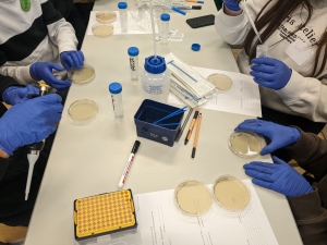
School classes and other citizen scientist groups will collect water samples from self-selected or specified water bodies and process them microbiologically under supervision. Smaller groups will also work in the laboratory and help with sampling campaigns. With the involvement of the citizen scientists, newly discovered Aquirufa species will also be scientifically named and described during the course of the project.
Interested citizens can participate in the project in workshops in Mondsee and in the Weitwörther Au (near Salzburg). More information is available on the project homepage. You can also follow the project on Instagram.
Citizen Science Seminar
In 2023, poject coordinator Alexandra Pitt held a lecture about the project Aquirufa (in German) as part of the lecture series "Citizen Science Seminar" at the University of Natural Resources and Life Sciences Vienna (BOKU).
Video
Videos (in German)
Publications with the contribution of Citizen Scientists
Alexandra Pitt, Stefan Lienbacher, Johanna Schmidt, Meina Neumann‑Schaal, Jacqueline Wolf, and Martin W. Hahn (2024). Description of a new freshwater bacterium Aquirufa regiilacus sp. nov., classification of the genera Aquirufa, Arundinibacter, Sandaracinomonas, and Tellurirhabdus to the family Spirosomataceae, classification of the genus Chryseotalea to the family Fulvivirgaceae and Litoribacter to the family Cyclobacteriaceae, as well as classification of Litoribacter alkaliphilus as a later heterotypic synonym of Litoribacter ruber. Archives of Microbiology, Volume 206, article number 79. https://link.springer.com/article/10.1007/s00203-023-03801-8
Alexandra Pitt, Stefan Lienbacher, Johanna Schmidt, Meina Neumann-Schaal, Jacqueline Wolf, Hannah Wenng, Aharon Oren, Zoe Huber, Martin W. Hahn (online first). Biodiversity of strains belonging to the freshwater genus Aquirufa in a riparian forest restoration area in Salzburg, Austria, with a focus on the description of Aquirufa salirivi sp. nov. and Aquirufa novilacunae sp. nov. International Microbiology https://doi.org/10.1007/s10123-025-00642-x
Alexandra Pitt, Stefan Lienbacher, Johanna Schmidt, Meina Neumann-Schaal, Jacqueline Wolf, Aharon Oren, Sophia Reichl & Martin W. Hahn Aquirufa esocilacus sp. nov., Aquirufa originis sp. nov., Aquirufa avitistagni, and Aquirufa echingensis sp. nov. discovered in small freshwater habitats in Austria during a citizen science project. Archives of Microbiology, 207:71 https://link.springer.com/article/10.1007/s00203-025-04275-6
Pitt, A., & Hahn, M. (2023). Wissen schaffen mit Citizen Scientists: Biodiversität und Ökologie von Süßwasserbakterien. Biologie in Unserer Zeit, 53(3), 272–279. https://doi.org/10.11576/biuz-6525 (in German)

This project fulfils version 1.1 of the quality criteria for citizen science projects on Österreich forscht.
Recycling Heroes
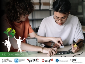
The sale of electrical and electronic equipment is constantly increasing and accordingly e-waste has already become the fastest growing waste stream in the world. Our society needs to face this challenge without delay, so the Recycling Heroes project aims to raise awareness about e-waste, especially among students but also in society in general, by combining the principles of the circular economy with citizen science methods.
Participation
As citizen scientists, the students develop a comprehensive questionnaire to ask their family or neighbours what electronic products are used for and over what period of time, and what happens to devices that are no longer used. Afterwards, the students analyse the results of the survey and consider what could be done to ensure proper disposal and increase the recycling rate. In addition, the students look into the development of electronic products that can be used in other current citizen science projects. These new products can be developed, for example, as a mesh-up of e-waste parts and new parts - sustainability is the focus here! Subsequently, the developed and tested prototypes will be duplicated in small numbers and distributed to other partner schools in the project. These schools will use the prototypes to collect data on temperature, noise, humidity and particulate matter in the school environment, for example, and then make them available to Citizen Science projects.
Aims
The project aims to strengthen the students' environmental awareness and recycling culture, as well as their understanding of eco-design and development processes. In addition, the students learn to develop suitable survey instruments and to sharpen their scientific thinking with regard to citizen science.
This project fulfils version 1.1 of the quality criteria for citizen science projects on Österreich forscht.
United by Crisis?
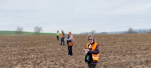
Participate in archaeological field surveys and/or in cleaning, documenting & interpreting archaeological finds.
A transdisciplinary look at the early Neolithic communities in the Schletz settlement cluster
The project aims to explore the surroundings of the famous Neolithic settlement of Asparn/Schletz (Lower Austria). Numerous human remains suggest a violent attack on this site in the Late Linear Pottery Culture, approx. 7.000 years ago.
Due to its size and earthworks, we assume that Schletz was the central site of a cluster of smaller settlements in surrounding region. By researching these settlements, we hope, among other things, to increase our knowledge on the background of the massacre and on the origin of the people who died in Schletz.
We cordially invite you to work with us as a Citizen Scientist!
In the project, we are searching for Neolithic finds (pottery, stone tools, etc.) at known or suspected sites near Asparn/Schletz together with interested people and collectors. During our surveys, we go over the fields at regular intervals and map the findings that we discover. Later on, we clean them together und create a scientific documentation and evaluation. Here you can find further information on how you can participate as a Citizen Scientist. However, as we have planned a format of intensive cooperation, we have reached the maximum number of Citizen Scientists that can participate in the project. Nevertheless, we can still offer you to join the waiting list for the participation in the project (or possible follow-up projects).
In another part of the project, local middle school students extract and process soil samples from the area of the LPC sites to create an isoscape (= isotope landscape). Through a comparison with Sr isotope ratios of the human remains, this will allow a discussion of whether the people that died in the massacre might have grown up locally or not.
If you are passively interested in the project, you are invited to visit the news page of our website, where we regularly publish news about the project.
Citizen Science Seminar
In January 2025, Johanna Irrgeher, Julia Längauer and Jakob Maurer gave a lecture on 'The Neolithic "Massacre of Asparn/Schletz" - transdisciplinary research with citizen scientists' at the Citizen Science Seminar of BOKU University (in German).
Project partners & cooperation partners
![]()

![]()
Picture gallery:
- Zwentendorf, possible early Neolithic site near to the Zaya-river Zwentendorf, possible early Neolithic site near to the Zaya-river
- Victims of a Neolithic massacre were discovered during archaeological excavations in Asparn/Schletz Victims of a Neolithic massacre were discovered during archaeological excavations in Asparn/Schletz
- Together with Citizen Scientists we do systematic “line walking” for the identification of Neolithic sites Together with Citizen Scientists we do systematic “line walking” for the identification of Neolithic sites
- The finds are carefully packed; the find spots are precisely documented with GPS The finds are carefully packed; the find spots are precisely documented with GPS
- Newly discovered, unwashed finds „fresh from the field” Newly discovered, unwashed finds „fresh from the field”
- Early Neolithic stone tools and potsherds from the Zwentendorf-Hofwiese site Early Neolithic stone tools and potsherds from the Zwentendorf-Hofwiese site
- Early Neolithic house (house model in MAMUZ Schloss Asparn/Zaya) Early Neolithic house (house model in MAMUZ Schloss Asparn/Zaya)
- Soil samples are taken by middle school students for the creation of an isotope map Soil samples are taken by middle school students for the creation of an isotope map
- To research the origin of the dead of Schletz, chemical analysis is done on soil samples and human teeth To research the origin of the dead of Schletz, chemical analysis is done on soil samples and human teeth
- The core team of the project with scientists from different disciplines is looking forward to working together! The core team of the project with scientists from different disciplines is looking forward to working together!


https://www.citizen-science.at/en/component/k2/author/934-florianheigl?start=70#sigProId0cf662b906
The project is funded by:
This project fulfils version 1.1 of the quality criteria for citizen science projects on Österreich forscht.
Everyday Morality

What is this project about?
How can good people do bad things? How can people act contrary to their moral beliefs without having a bad conscience? White lies, rule bending, finding excuses for our own behaviour, which we would judge others for … To be honest, we have all done stuff like that. Nobody is always 100 % moral - misconduct spans from little untruths to refined fraud, from omission of some facts to crimes. All these things have one thing in common: When performing these actions, the same mechanisms are at work that allow us to ignore our moral compass. At least that is what theories assume. In this project, we examine when, how often, in which contexts and by whom these different mechanisms are applied.
Why is this important?
Our goal is to check to what extend theory corresponds with reality. How is unmoral behaviour in everyday life justified? What influence do situational differences and relationships between actors have? Which actions are seen as immoral?
How can Citizen Scientists participate?
Your task is to observe your surroundings after a short online information. Who acts immoral? When? What justifications are provided for this behaviour? Not just encounters in everyday life matter, but also media, newspaper reports, narratives, movies, social media etc. can be analysed. For this, short questionnaires will be sent to you during the course of one week.
At a later point in time, Citizen Scientists are invited to analyse the submitted scenarios, to build categories and thereby check to what extent theory and reality correspond. Another aim is to discover new categories and strategies.
Podcast episode
If you would like to learn more, you can listen to the Wissen macht Leute podcast episode about the project (in German).
This project fulfilled version 1.1 of the quality criteria for citizen science projects on Österreich forscht.